

Wooster, Ohio
Wooster (On the Highway since 1913) Pop: 25,000 Wayne County Seat.
Wooster sprang up on fertile land at Apple Creek and Killbuck Creek. Wooster was founded in 1808 by brothers Joseph, John and William Larwill, English surveyors.
The town thrived on agriculture and coal. A monument on South Bever Street by the railroad bridge also marks the intersection of the three major Indian Trails in Ohio.
 Historic neighborhood, Founders Row houses on Bever St.,
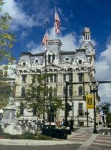
- The Wayne County Courthouse on Public Square.
-
- The Stone House - (Ohio Agricultural Research & Development) OARDC Campus
- The Wayne County Historical Society and Museum. 546 E. Bowman St., (330) 264-8856. Also see The Reasin Beall Homestead (1817) on the Wayne County Historical Society Campus. Beall was a War of 1812 General.
- Just south of the Public Square is the Wooster Brush Company, started in 1850s and was an early donor to the Lincoln Highway Association.
- At the intersection of US 30 and Carr Road was an old Lincoln Highway camping area, the first overnight accommodations between Massillon and Mansfield.
 J.M. Smucker Company Store and Café just north of US 30 at S.R. 57
- Lehman's Hardware close by in Kidron. Lehman's is your source for old-fashioned, hard-to-find items.
 Hampton Inn
- Super 8 Motel
- Econo Lodge
- Best Western
- Days Inn
- Rodeway Inn
- Hilton Garden Inn
 Acres of Fun. 3889 Friendsville Rd. (330) 345-4386 Open year-round; laser tag, children's play area, snack bar and game room, 18-hole miniature golf course, go-karts, bumper boats, bankshot basketball and batting cages. Call for hours.
- Alice Noble Ice Arena 851 Oldman Rd. (330) 345-8686 Soccer, lacrosse, hockey and figure skating. Open 7 days a week.
- Wooster Skateland Rollerskating Rink
- Secrest Arboretum and gardens; Ohio State University.
-

The Ohio State University’s Secrest Arboretum is an outdoor research laboratory and educational display garden.
For more information, please visit our website at waynecountycvb.com
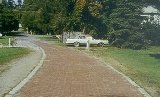
Perhaps the oldest exposed remnant of Lincoln Highway brick is in Wooster, where Sylvan Road dead-ends at the west bank of Apple Creek. To reach this location, turn south from Pittsburgh Avenue onto Bauer Road for 0.1 mile.
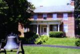
Reasin Beall Homestead.
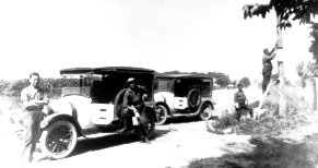
The Lincoln Highway Association began marking the route by painting what would later become their logo on poles. Here, a crew marks an Ohio pole in 1916. The brushes used were provided by Wooster Brush.
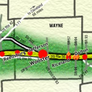
Leaving Wooster to the west, you will approach the intersection of US 250. You will need to make a decision whether to follow 250 which is the 1913-1928 route into Ashland, or the 1928 route into Jefferson and Reedsburg on the Road marked Old Lincoln Way/U.S. 30-A.